
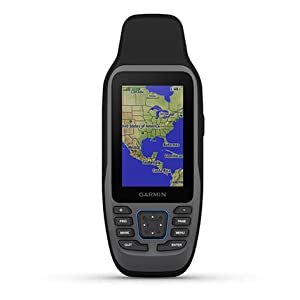
Garmin GPSMAP 79sc is a rugged, floating handheld navigator made primarily for coastal boaters. Its preloaded BlueChart g3 charts, physical buttons, replaceable AA batteries and dependable compass make it a strong backup GPS—but it is not the best choice for every outdoor user.
Prices and availability can change. Check the listing for the latest details.

8.4/10
Quick Verdict
The GPSMAP 79sc is worth considering if you want a dedicated, glove-friendly marine GPS that floats and already includes coastal charts. It is especially useful as a backup to a fixed chartplotter on fishing boats, sailboats, kayaks and small craft.
You boat in covered coastal waters and value physical controls, replaceable batteries and a floating design.
You mainly hike inland, want a touchscreen, need multi-band GNSS or require satellite messaging and SOS.
Garmin GPSMAP 79sc Key Specifications
Who Is the GPSMAP 79sc For?
This model makes the most sense for boaters who want navigation independent of a phone signal. The included BlueChart g3 coastal charts are the main reason to choose the 79sc instead of the lower-priced 79s.
- Coastal fishing, sailing and recreational boating
- Kayakers who want a unit that floats if dropped
- Small-boat owners needing a portable backup navigator
- Users who prefer buttons in rain, spray or while wearing gloves
- Travelers who want easy-to-replace AA power instead of a sealed battery
View Garmin GPSMAP 79sc on Amazon
Confirm that the listing is the 79sc version with preloaded coastal charts—not the 79s basemap model.
Features That Matter on the Water
Floating, water-ready body
The handheld is designed to float and carries IPX6/IPX7 water ratings. That makes it more suitable around spray and accidental drops than a typical phone, although it should still be rinsed with fresh water and dried after saltwater exposure.
Preloaded coastal charts
BlueChart g3 coastal charts add marine detail that the worldwide basemap on the 79s does not provide. This is the 79sc’s biggest conversion point for buyers navigating supported coastal regions.
Reliable physical controls
Dedicated buttons remain usable with wet hands and gloves. The MOB shortcut can save the current man-overboard position and immediately start navigation back to it.
Multi-constellation tracking
The series supports several global satellite constellations. This can improve acquisition and positioning reliability compared with GPS-only operation, though using extra satellite systems may reduce battery life.
3-axis electronic compass
The tilt-compensated compass can show heading while you are stationary. Calibrate it after major travel, temperature changes or battery replacement for more dependable direction information.
Useful storage and expansion
The unit can retain up to 10,000 waypoints and 250 routes. A microSD card up to 32 GB can be added for compatible maps or extra storage.
GPSMAP 79sc vs 79s vs 86Sci
| Model | Best for | Included mapping | Satellite messaging | Key reason to choose |
|---|---|---|---|---|
| GPSMAP 79scBest balance | Coastal boaters | BlueChart g3 coastal charts | No | Floats, AA power and charts included |
| GPSMAP 79s | Budget marine GPS users | Worldwide basemap | No | Similar hardware without bundled coastal charts |
| GPSMAP 86Sci | Offshore safety and connected boating | BlueChart g3 coastal charts | Yes, with subscription | inReach messaging, SOS and marine connectivity |
Best Garmin Option for Each Buyer
Garmin GPSMAP 79sc
Choose this if coastal charts, a floating body and replaceable AA batteries cover your needs. It is the most direct match for recreational coastal navigation.
Garmin GPSMAP 79s
Choose the 79s if a worldwide basemap is enough or you already own compatible mapping. Buying coastal maps separately can reduce the apparent savings.
Garmin GPSMAP 86Sci
Choose the 86Sci if two-way satellite messaging, interactive SOS and integration with compatible marine systems justify the higher cost and ongoing subscription.
What We Like
- Floats if accidentally dropped overboard
- Readable display and button controls for wet conditions
- Preloaded BlueChart g3 coastal charts
- User-replaceable AA batteries
- Strong waypoint and route capacity
- 3-axis electronic compass and MOB shortcut
- MicroSD expansion and NMEA 0183 support
What to Consider
- No touchscreen or smartphone-style interface
- No built-in inReach messaging or interactive SOS
- Small screen compared with a fixed chartplotter
- No Wi-Fi or Bluetooth workflow in the owner manual
- Not a multi-band GNSS hiking flagship
- Coastal chart coverage should be confirmed before purchase
- AA batteries are not included
Five-Minute Setup Checklist
- 1
Install two fresh AA batteries
Garmin recommends 1.5 V lithium batteries for best results. Select the correct battery type in system settings.
- 2
Acquire satellites outdoors
Give the unit a clear view of the sky and wait for a position fix before leaving the dock.
- 3
Calibrate the compass
Follow the on-screen calibration process away from vehicles, buildings and other magnetic interference.
- 4
Confirm chart coverage and updates
Open the map, verify the intended boating area and use Garmin Express for available software or map updates.
- 5
Save critical waypoints
Mark the marina, ramp, anchorage and emergency locations. Practice the MOB function before you need it.
Accuracy, Battery Life and Everyday Use
How accurate is the GPSMAP 79sc?
Accuracy changes with satellite geometry, sky visibility, interference and selected satellite settings. Garmin’s manual gives an example GPS accuracy field of approximately ±3.65 m (12 ft), not a permanent guarantee. Open water usually provides a clearer sky view than dense forest or urban streets, but every position should still be treated as an aid rather than an absolute measurement.
Does the battery really last 19 hours?
Garmin rates the unit for up to 19 hours, but real runtime depends on battery chemistry, backlight brightness, temperature and satellite configuration. Carrying spare lithium AAs is an inexpensive advantage on multi-day trips. Battery Saver and Expedition modes can extend runtime when continuous screen use is unnecessary.
Is it good for hiking?
It can record tracks, navigate waypoints and accept compatible optional maps, so it can work on land. However, its value proposition is marine use. Hikers may prefer a newer outdoor-focused model with topographic mapping, multi-band GNSS, longer battery life or satellite communication.
Should You Buy the Garmin GPSMAP 79sc?
Yes—for the right boater. The GPSMAP 79sc combines the features that matter most in a portable marine backup: it floats, tolerates wet conditions, works with physical buttons, uses replaceable batteries and includes coastal charts.
It is less compelling for inland hikers, users expecting a modern touchscreen or anyone who needs emergency satellite communication. Those buyers should compare the 79s, 86Sci or an outdoor-focused Garmin before ordering.
Coastal boaters who want a reliable handheld backup
Check Current Price
Verify seller, chart coverage, package contents and return policy on the product page.
Frequently Asked Questions
Does the Garmin GPSMAP 79sc float?
Yes. Garmin designed the GPSMAP 79 series to float. Use the included lanyard when possible, and rinse and dry the unit after exposure to salt water.
What is the difference between GPSMAP 79s and 79sc?
The key difference is included mapping. The 79s comes with a worldwide basemap, while the 79sc includes BlueChart g3 coastal charts. Their core rugged, floating hardware is otherwise closely related.
Does the GPSMAP 79sc have a touchscreen?
No. It uses physical buttons, which many boaters prefer in rain, spray and gloved use. Buyers wanting a smartphone-like touchscreen should consider other navigation devices.
Does it include batteries?
No. It operates on two AA batteries or an optional compatible NiMH battery pack. Garmin recommends 1.5 V lithium AAs for best results.
Does the GPSMAP 79sc have satellite messaging or SOS?
No. It has a man-overboard navigation function, but it does not provide inReach two-way messaging or interactive SOS. The GPSMAP 86Sci offers those capabilities with an active satellite subscription.
Can the GPSMAP 79sc be used on land?
Yes. It supports waypoints, routes, tracks and compatible optional maps. Still, its included BlueChart coastal mapping and floating design make it primarily a marine-focused purchase.
Can I add a memory card?
Yes. Garmin’s owner manual states that a microSD card up to 32 GB can be installed for extra storage or compatible preloaded maps.
A Dependable Marine GPS With the Right Priorities
The Garmin GPSMAP 79sc is a practical choice when reliability, coastal charts, physical controls and replaceable batteries matter more than touchscreens or connected features. Its focused design is exactly why it remains useful as a primary handheld or backup navigator on the water.
Sources checked: Garmin GPSMAP 79 Series, official owner’s manual, and current Amazon product listings. Product specifications and availability may change.